Tool 14
TOOL 14. SURVEYING WATER RESOURCES AND INFRASTRUCTURE
To obtain good insight into the location of water resources and water infrastructure.
OBJECTIVE
To obtain good insight into the location of water resources and water infrastructure.
METHOD
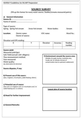
Step 1: Decide on the data to be collected from each source and develop a data collection sheet (for example, see Figure 7).
Step 2: Measure the coordinates for each source, using a GPS and collect additional data through measurements, observation and on-the-spot interviews.
Step 3: Present the collected data on a map.
Step 4: Verify and discuss with water users and service providers.
TIPS AND TRICKS
- This activity can be built on, or can be further enriched by community mapping (Tool 7).
Figure 7 - Example of a water source survey form

Source: WARM-P/Helvetas and RVWRMP, 2007
